Drive the route your permit actually allows.
SafeHaul turns an already-issued oversize or overweight DOT permit into a map you can review before dispatch and follow from a phone in the cab.
SafeHaul does not apply for permits or replace DOT instructions — it digitizes the permit you already hold.
- Add a permit
- QR · PDF · Photo · Number · Email
- Built for
- A phone in the cab
- Your data
- Private by default
How it works
From a permit to a drivable route
Each step is something you'd do by hand anyway — SafeHaul just makes it faster and harder to misread.
- STEP 01
Add the permit
Scan the DOT QR code, upload a PDF or photo, type the permit number, or forward it to permits@safehaul.app. Direct lookups cover Texas, Louisiana, Colorado, and North Dakota; PDFs and photos parse from any state.
- STEP 02
SafeHaul structures the route
It reads the route sheet, resolves the legs to road-accurate waypoints, and pulls permit fields — vehicle, dimensions, weight, restrictions — wherever the permit lists them.
- STEP 03
Review before dispatch
Open the permitted path on a map and check every waypoint and segment. SafeHaul runs automatic checks on each route and flags the ones that need a closer look — so you catch issues at the office, not at a low bridge.
- STEP 04
Drive and record it
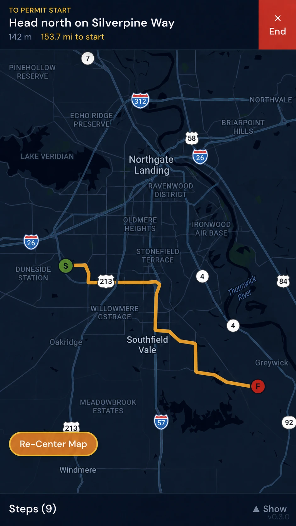
Follow the route on a phone with GPS-driven step prompts, or open it in Google Maps. Each completed drive is saved with the path you took and how closely it stayed on the permitted route.
See it in the app
Real screens from SafeHaul
Actual in-app captures — the navigator, multi-state trips, and your permit list.
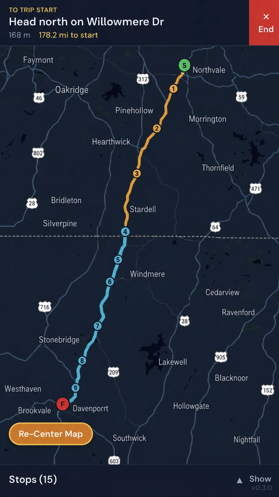
Multi-state trips, one drive
Chain permits across state lines. Each state's permitted path renders in its own color, with the handoff marked at the line.
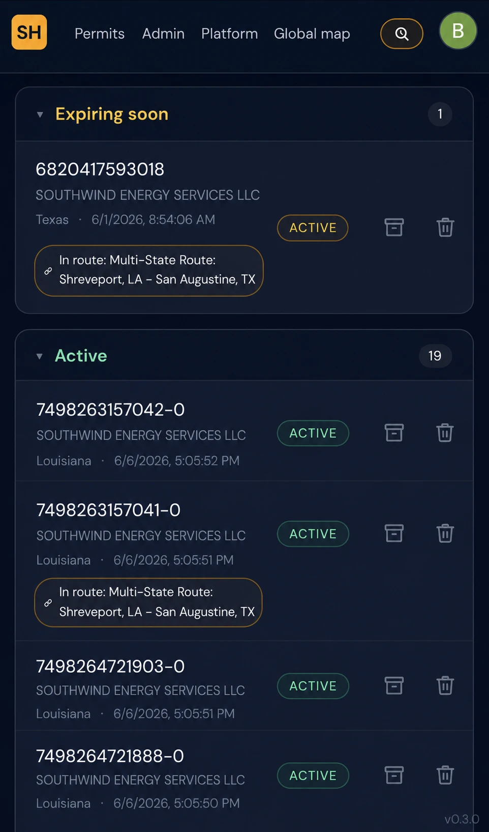
Every permit in one place
Permits group by status — expiring soon, active — each tied to its drivable route, with multi-state trips called out.
Features
What SafeHaul does today
Each one is in production now.
Add a permit four ways
Scan a QR code, upload a PDF or photo, type the permit number, or forward it by email. Same structured route at the end.
Route & field extraction
Legs, waypoints, and mileage become a road-accurate route — plus the permit's vehicle, dimensions, and restrictions where they're printed.
Mobile navigation
Follow the permitted route on a phone with GPS-driven step prompts and guidance to the start. It runs in the phone browser — nothing to install.
Open in Google Maps
Prefer your usual nav app? One tap exports the permitted route to Google Maps with every waypoint intact.
Shareable, revocable links
Hand a dispatcher or backup driver a clean URL showing only the route line and name. Toggle it back to private and the link stops working.
Drive history & adherence
Each completed drive is saved with distance, time, stops, the path taken, and how closely it followed the permitted route. Delete any drive anytime.
Privacy & sharing
Your permit stays private. You choose what's shared.
Permits carry information you don't necessarily want public. SafeHaul treats them that way — and tells you exactly what a shared link shows.
- The original permit stays private. It’s scoped to your account — only you and people on your account can open it.
- Shared links show the route only. A shared page shows the route line, name, distance, and time — never the permit document, carrier, or upload. Waypoint labels are stripped.
- Sharing is opt-in and revocable. You share one route at a time, and you can switch it back to private whenever you want.
- Location data drives the features, not ads. If you start a trip, GPS is used for navigation, your drive history, and route adherence — not sold. Contributing anonymized usage data is off unless you opt in, and you can delete your driving data anytime.
What a shared link exposes
Route line + name. Nothing else.
- Shown — Route line on a map
- Shown — Route name, distance, and time
- Hidden — Permit document (PDF)
- Hidden — Carrier name & account details
- Hidden — Waypoint labels & permit fields
You control whether a route is shared at all, and can revoke it at any time.
For carriers & dispatchers
Get a permitted route into the driver's hand
SafeHaul is in active pilots with carriers. Here's what it does for an operation today.
Hand drivers a route, not a PDF
Give a driver a route link they can open and navigate on a phone instead of a permit sheet to squint at.
Permits, routes, and trips in one account
Keep each load's permitted route and its trip together, ready to review before the truck moves.
Review the drive after the fact
Each completed trip keeps a drive history — the path taken and how closely it held the permitted route.
FAQ
Questions worth answering up front
Does SafeHaul apply for permits on my behalf?
What permit formats are supported?
What happens if a permit doesn't parse cleanly?
Can drivers use it on a phone?
What does a shared route link expose?
Does SafeHaul replace the official permit?
How is pricing handled?
Ready to turn issued permits into drivable routes?
Sign in and add a permit to see the route come together. If you’re a carrier evaluating SafeHaul for a fleet, get in touch and we’ll set up a pilot.